Edited by Allison Symes
Image Credit: All images were supplied by Peter Russell
INTRODUCTION
My name is Peter Brent Russell and I was a child of the Hook Road hutments for the first five years of my life – June 1950 to Summer 1955. I’ve been following and contributing to the main discussion thread on this website since Spring 2016 and noticed the ‘related posts’ by John Rolfe and Liz Stothard/Dee, where photos have been uploaded.
(Editor’s Note: The links to all of the previous posts on The Hutments will follow at the end of this post and throughout the series).
I’ve arranged with Janet Williams to share my posts on The Hutments here, where I can present the results of my research from 2016 onwards and, more personally, upload my family’s recollections and photos for others to share.
Many of my findings are based directly on the clear recollections of my mother, Claudia Ruth Russell. I can no longer ask her any questions, as she sadly passed away, aged 97, in October 2018.

This web page is a tribute to her and my father.
I hope to add to this series of posts as new information comes to light.
I have arranged my thoughts into different sections, which will form this series, and these are:-
Estate History and Layout
My Family Background
Recollections of Hutment Life and Recollections of Other Hutment Families
I hope you enjoy what is to come and if anyone can add to the information here, that would be most welcome.

Going Back in Time
For starters, here’s a wonderful colour photo taken by my maternal grandfather in August 1948, a year after my parents moved from Winchester into hutment No.42. This shows the southern part of the estate service road, looking westwards.
My mother – Claudia Ruth Russell (nee Du Rose) – and my father – John Frederick Russell, are standing outside No.42 (extreme right, with the rowan trees). The car (an Austin?) is my grandfather’s. Note the maroon delivery van (the owner’s name is not discernible); the children playing; rustic fencing installed by residents; the road surface, which I think was golden chippings pressed into tarmac, rather than being loose.
Tree planting may have dated from early on, possibly just after the construction of the estate, as some specimens are already maturing by 1948. All very neat and tidy. The hutment beyond the delivery van was, I think, a later addition (post-1941) and looks slightly different to the others. On some maps, that plot was vacant, suggesting a ‘ransom strip’ – a gap that might have allowed the estate to extend westwards if needed. It never was and I reckon the plot was infilled, possibly after WW2.
(For any vintage photo fans, the image is from a Dufaycolour slide.) © The late W. S. Du Rose; cty. Peter B. Russell
(Editor’s Note: For anyone wanting to know a little more about Dufaycolour, do see the link to the Wikipedia article on this – Dufaycolor)
Estate history and layout
I have been working with another child of the hutments – Nick John; also with Dave Key, whose main interest is the Supermarine/Vickers workers who lived in the hutments and worked at Hursley Park.
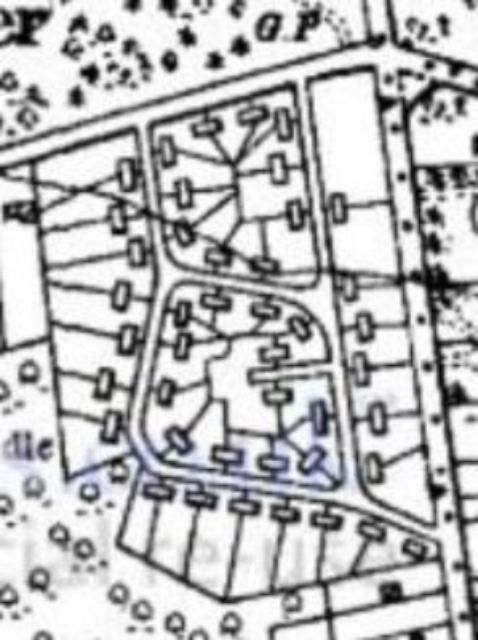
We have tried to discover the history of the estate’s development and find a large-scale map of the layout, with individual numbered hutments. Both have proved elusive, but I have gleaned some facts about the planning and construction from various sources (see later), and have created the reasonably accurate layout shown here, by drawing it over a less-than-sharp aerial photo.
Refining this is an ongoing task as more features are identified. Sadly, the layout never appeared on the large-scale Ordnance Survey maps (1:2,500), as editions were published in 1939 and after the estate had been demolished by the early 1960s, but not in between. It does, however, appear on the 1:25,000 and 1:10,560 scale sheets for the 1950s, but with detail that does not show individual hutments.

Editor’s Note: Reproduction of detailed diagrams such as the hutment estate layout, to make them fully readable for onscreen viewing, is not always easy to achieve. Either text can be distorted or the file becomes so huge download time becomes very slow. Consequently, instead of trying to show the large-scale layout on the main page here at reduced quality, we’ve provided a link below to a separate place where the layout can be more easily viewed as a clear PDF file. We recommend following this link, as the detailed estate layout is at the heart of the story, is a key to following much of the narrative, and may enable the reader to correct or add to the information provided. Please click on the link, which will open automatically if your computer has Adobe Acrobat software. If not, this can be downloaded for free from the Adobe website.
No accurate, large-scale layout plan has yet been found. This is roughly how a 1:2,500 OS sheet would have looked as regards the layout, had one been printed and published, but this seems never to have happened, unless a draft lurks in the OS archives. This is the layout of the estate, circa 1948, based on a late-1940s aerial photo, when the RAF had carried out aerial photography of much of the UK. The annotations raise some queries that have not yet been answered adequately.
The addition of hutment numbers and family surnames is an ongoing exercise by this writer. Some are definite, including the writer’s home at No.42. Many may be questionable, usually marked by a question mark. The hutment numbering is partly based on known numbers and positions (my No.42 included), and partly on my deduction; there may well be errors!
We do know there were roughly 100 units at peak development. We think that not all were built at one go, but there were development stages. We know that even numbers were mostly on one side of the service roads, odd numbers generally on the other side, but that wasn’t universal. My (hypothetical) system does seem to give a ‘best fit’ on the currently available knowledge. I’d be grateful if others with memories of their hutment numbers or those of their neighbours can clarify or correct my plan.
The hutments were semi-detached (all or most?), with some shared access to back areas in between the pairs. The plots were all on irregular polygons; no two seemed to be exactly identical in shape. Some hutments thus had more or less garden than others.
The aerial photo is helpful to some extent in showing garden boundaries, but not clearly enough in many cases. I have interpolated these boundaries as well as I can, but some shapes may look distinctly odd! There are a few specific mysteries, such as: the location of the public telephone kiosk; the positions of bus stops on Hursley Road; which sections of the service road were footpath-only; whose garden contained the monkey puzzle tree (it appears in John Rolfe’s photo).
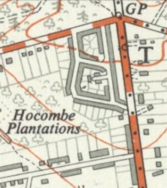
How the Ordnance Survey captured the estate:
Crown copyright reserved on all scales.
Above left: The late 1940s 1:10,560 scale (or 6 inches to one mile) sheet identifies the pairs of semis and shows some garden boundaries. There are clearly some missing hutments, notably at the top right, at the end of the cul-de-sac, beside the southern spur towards Hursley Road, and in the SW corner where a gap is shown. This may be cartographer’s error, but it is more likely that there was some later infilling. Did the original design and plan cater for a full 100 units?
Above right: The smaller 1:25,000 scale (2½ inches to one mile) OS sheet, circa 1958, gives a basic record, but offers no useful detail for identifying individual hutments. It does still show a gap in the frontage at the SW corner, although we know from aerial photography that this was infilled by at least 1948. It also shows the short cul-de-sac at centre. Garden boundaries are more schematic.
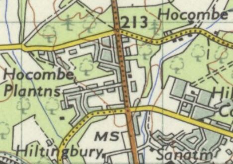
Above: The even smaller 1:63,360 (or one inch to one mile) OS sheet, circa 1959, shows the service road layout, but has the areas of hutments blocked in grey. The gap at the SW corner still shows, even this late. Since the 1:25,000 maps were derived directly from the 1:10,560 sheets, there may have been no updated survey of the estate layout since the 1940s.
Next Time
I look forward to sharing more next time where I’ll be looking at my family background and how we came to be at The Hutments.
Related Posts:-
The Hutments: Could You Help Find Old Neighbours in Chandler’s Ford?


Hi Peter,
Great work!
Just had a comment on the small piece on the Hutments on The Supermariners site (https://supermariners.wordpress.com/the-hutments-hursley-park/) that mentions the names of those at no.92 (Stockley) and their neighbour (Daniels). Hopefully we can add even more in time!
Peter
Did you ever manage to overlay the current road layout on the hutments drawings?
My interest is that I first visited the site with Bill Dibben of Chilworth Estates in 1962 who then owned the land and subsequently built the estate. I also have lived in Hocombe Wood Road since 1985.
Regards Ken
Hi Peter …
Although I have been following this series from the beginning, I have only just noticed today you have our family namesake, CLEWS ? in Hutment 89 ? … it is not a known relative, but as I am into Family History, I am wondering if you can tell me anything about that family (My mother, Dorothy Clews, used to work at Vicker’s at Hendy’s with Helen Stone, and we used to visit her and her husband, Fred Stone, at Hutment 54 ? when I was about 8 or 9 (1942/43).
Cheers !
Doug Clews
Hello Peter, Have not read your account before but have been keeping up with the series on the Hutments. I was glad to see your maps. Here are a couple of corrections. I lived at #23 and the monkey puzzle tree was in our front garden. My name then was Shelagh Burns and my parents were Alan and Kitty Burns. My dad worked for Vickers in the drawing office (I think). I do hope this helps with your ongoing research. sbduncan2@hotmail.com
Cheers,
Shelagh